WireWeather Software

Unleash the full potential of our grid
Unlock Line Capacity
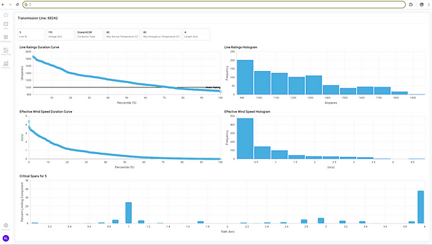
Our software tool forecasts thermal line and component ratings (AAR & DLR) to meet FERC 881 compliance and increase transmission path capacity and reliability.
Weather Uncertainty
We build confidence intervals around our forecast ratings (accounting for spatial and temporal uncertainty), giving you the confidence to make informed decisions.
Data Integrations
Our tool delivers data where and when it's needed including EMS integration, Oasis submissions, and tool-based access control for market participants, operations teams and others.
Transparency
We provide robust documentation detailing our rating calculations, methodology, and assumptions, ensuring accuracy and transparency.
Compliance
Meet FERC 881 compliance including in-line component ratings via tables, polynomial regressions and other methods. Prepare for FERC 1920 and DLR ANOPR compliance with our transmission analytics tool.
How it works
01.
Comprehensive Network Mapping
We map your entire transmission network for immediate AAR and FERC 881 compliance. If available, we integrate existing weather stations and line sag sensors. No sensors required.
02.
Sensor Deployment Analysis
Our tool identifies optimal locations for WireWarrior sensor deployment, reducing forecast line rating confidence intervals.
03.
Drone Sensor Deployment
We deploy our WireWarrior line sensors via our safe and efficient drone platform.
04.
Advanced Data Analytics
Our tool combines actual sensor weather data, advanced computational fluid dynamics, and AI/ML engines to produce the most accurate weather and line rating forecasts.
05.
Informed Grid Management
Push more energy through your lines, plan for contingency and n-1 scenarios, monitor and identify capacity bottlenecks and limiting components.

Transmission Planning & Analytics
Analyze historical data. Calculate the impact of implementing AAR/DLR on your network. Comply with state and federal regulations (FERC 1920) that require analysis of Grid Enhancing Technologies.
Pinpoint Wildfire Risk
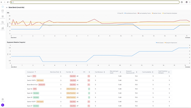
Combine localized weather conditions with third-party data to develop a comprehensive span-level wildfire risk assessment. Inform Public Safety Power Shutoffs (PSPS), line monitoring and other critical wildfire prevention decisions.


